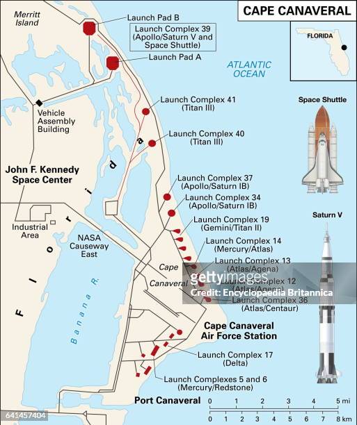
fl brevard county vector map green - cape canaveral map stock illustrationsFL Brevard County Vector Map Green
florida map – watercolor style - cape canaveral map stock illustrationsFlorida map – watercolor style
Passport card of a part of the east coast of the United States Passport card of the coast of Carolina between C. De Canaveral and C. Henry , Passport...Passport card of a part of the east coast of the United States Passport card of the coast of Carolina between C. de Canaveral and C. Henry (title on object), Passport card of a part from the east coast of the United States, from Cape Canaveral to Cape Hat
Weather radar map on NASA television November 30, 2008 in the media center at Kennedy Space Center in Florida as both landing attempts of the space...A weather radar map on NASA television N
terracotta texture surface. - cape canaveral map stock pictures, royalty-free photos & imagesTerracotta texture surface.
watching a rocket launch at cape canaveral - cape canaveral map stock pictures, royalty-free photos & imagesWatching a rocket launch at Cape Canaveral
SpaceX Falcon 9 rocket launches the HAKUTO-R Mission 1 from pad 40 at Cape Canaveral Space Force Station on December 11, 2022 in Cape Canaveral,...SpaceX Launches Hakuto-R Lunar Lander Mission
Interior view showing the control display system for Project Mercury, with an 8ft-by 26ft world map displaying the capsule's path in orbit and the...Mercury Control Center, Cape Canaveral Space Force Station
Unique view of the Apollo 13 landing site in Fra Mauro. One of the major reasons for the Apollo 13 lunar landing mission is the study of geology and...Apollo 13 Mission
Weather radar map in the media center shows storms in the area April 19, 2010 at Kennedy Space Center in Florida just after NASA waved off the second...A weather radar map (L) in the media cen
Weather radar map in the media center shows storms in the area April 19, 2010 at Kennedy Space Center in Florida just after NASA waved off the second...US-SPACE-SHUTTLE-DISCOVERY
The astronauts of NASA's human spaceflight program Project Mercury at the Mercury Control Center at Cape Canaveral, Florida, 24th September 1960....Project Mercury
Closer view of the landing zone selected for the Mars Polar Lander is shown on this map created using Viking images. A bright blue ellipse indicates...Mars Polar Lander
Atlas V rocket carrying the Lunar Reconnaissance Orbiter and Lunar Crater Observation Sensing Satellite takes off from Cape Canaveral, Florida, U.S.,...A NASA Atlas V rocket carrying the Lunar Reconnaissance Orbi